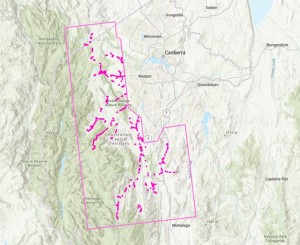
Following the success of our annual Aerial Inspection Program, we identified vegetation encroaching on the electrical network. Evoenergy engaged accredited arborists to clear priority areas and the drone will now review these areas to verify they meet safety and regulatory standards.
This audit will commence on Tuesday, 5 August and conclude by Friday, 15 August - flying Monday to Sunday, between 8am to 4pm. Should we encounter wet weather, the program could be extended.
This year Evoenergy has contracted Intelfuse and Carbonix to bring on an EVLOS Multirotor Drone fitted with a Light Detection and Ranging (LiDAR) device. LiDAR technology uses a sensor to create a 3D map of the distance between trees and the electricity network.
Their drone sits at approximately 4 meters wide by 1.5 meters long and is remotely controlled with a 300-meter line of sight. Light Detection and Ranging (LiDAR) technology is used to minimise hovering while also determining the distance between powerlines and trees. The drone is significantly quieter compared to a helicopter and will operate at approximately 97 decibels.
The audit process involves reviewing up to 76km of cleared powerlines by air, saving the time and resources it takes to conduct ground inspections. Flying at an approximate height of 60 -100 meters, it is locked into the specific GPS coordinates of our infrastructure. You will see us flying along rural zones including Belconnen, Booth, Coree, Paddys River, Stromlo and Tennent.
Evoenergy is trialling this new aircraft to see if it is a viable option for conducting the annual Aerial Inspections Program moving forward.
The audit will support essential bushfire mitigation strategies for the Emergency Services Agency and safety maintenance program for Evoenergy’s electricity network.


