Our annual aerial inspection program provides a bird’s eye view of our network and allows us to identify faults, potential defects and trees that are too close and causing a risk to our network. Aircraft patrols are an important part of our overall network maintenance program and bushfire mitigation strategy.
2026 aerial inspection program
Our 2026 aerial inspections will be conducted from 23 February to mid April, weather permitting.
We will cover roughly around 1500 kilometres of Power poles, Transmission lines, High Voltage lines, Low voltage lines and Service Lines.
This year, we will be using both a helicopter and a drone to assist with data capture. The helicopter will fly between 1000 - 2500 feet and our drone will fly between 500 and 1000 feet.
Both aircraft will be fitted with Light Detection and Ranging (LiDAR) technology. LiDAR uses a sensor to create a 3D map of the distance between trees and the electricity network. Using this technology assures minimal hovering.
Helicopter flight map
On the flightradar24 map – you will be able to see the flight path of our aerial inspection helicopter when it is flying. It will appear as a helicopter on the map and the identification name is VH-OAS. It takes-off and lands at the Canberra Airport.
The suburbs we’ll be flying over include
Aranda, Acton, Ainslie, Barton, Beard, Belconnen, Bonython, Bruce, Campbell, Canberra Airport, Chapman, Charnwood, Chifley, Chisholm, Conder, Cook, Crace, Curtin, Deakin, Denman Prospect, Dickson, Downer, Duffy, Dunlop, Evatt, Fadden, Farrer, Fisher, Florey, Flynn, Franklin, Fraser, Fyshwick, Garran, Gilmore, Giralang, Gordon, Gowrie, Greenway, Griffith, Hackett, Hall, Harrison, Hawker, Higgins, Holder, Holt, Hughes, Hume, Hume, Isaacs, Isabella Plains, Jacka, Kaleen, Kambah, Kingston, Latham, Lawson, Lyneham, Lyons, Macarthur, Macgregor, Macnamara, Macquarie, Mawson, Mckellar, Melba, Mitchell, Molonglo, Monash, Narrabundah, Ngunnawal, Nicholls, Oaks Estate, O'connor, O'malley, Oxley, Page, Pearce, Phillip, Pialligo, Red Hill, Richardson, Rivett, Russell, Scullin, Spence, Stirling, Strathnairn, Symonston, Tharwa, Theodore, Torrens, Turner, Uriarra Village, Wanniassa, Waramanga, Watson, Watson, Weetangera, Weston, Whitlam and Yarralumla.
We will predominately be flying over public land however there may be instances where it appears we are flying over private property as homes back onto nature reserves and bushfire prone catchments.
What to expect from our aircraft:
Weather permitting, the patrols generally fly Monday – Saturday between working hours (8am and 4pm). They start early so they can get two flying sessions in a day and avoid potential bad weather in the afternoon. We try to avoid flying on Sundays, however if time has been lost due to bad weather, it may be required after 12 noon. Both aircraft have noise reduction modifications, and our LiDAR technology means it does not need to hover or turn around a lot.
What we do after the inspections:
Vegetation management work is prioritised on a scale from immediate response to reactively clear to no action required/monitor. Using the information gathered from our patrols, we will prioritise vegetation trimming in this way to ensure the continued safety and reliability of our network.
Check trees in your backyard:
In the ACT, homeowners and occupiers are responsible for keeping trees clear of powerlines on their property. You don’t have to wait for us to send you a notification to trim your trees – we recommend you check trees on your property to check they’re not too close to powerlines, or if they might be getting close. For more information on vegetation management in the ACT, see our Trees and Powerlines page.
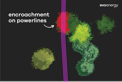
An example of the LiDAR images the aircraft takes. The purple lines indicate our powerlines, and the green areas are trees.